
The BEYOND Center has installed and operates large scale infrastructures for the systematic reception, management and redistribution of real-time Earth Observation data acquired by satellites and in-situ monitoring networks. The coverage and usage of the monitoring infrastructure is international. It covers observational needs of a wide research community and decision makers across the Southeast Europe, North Africa, Middle East and the Balkans.
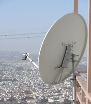
MODIS ANTENNA
 IAASARS/NOA Ground Segment has been expanded in the framework of the BEYOND project with the installation of an X-, and L-band satellite acquisition station for the reception, acquisition, and processing of the direct broadcast downlinks from satellite missions including the EOS Aqua & Terra satellites (MODIS - Moderate Resolution Imaging Spectroradiometer), the NPP (VIIRS, ATMS, etc), the future NPOESS, the NOAA, the FYI, and the MetOP satellites. The IAASARS/NOA Ground Segment is equipped with the proper processing, archiving, and cataloguing facilities for handling in real time image data from the missions above, as well as the future Copernicus satellite missions (Sentinels) through ESA's Ground Segment. Those Ground Segment facilities foster the development of a wide range of environmental monitoring services, such as: aerosol pollution indexes assessment, dust and volcanic ash alerts, smoke dispersion forecasts, wildfire detection and monitoring, geo-hazard activity monitoring and assessment (earthquakes/volcanoes/landslides), and urban heat Island mapping.
ATLAS UAV
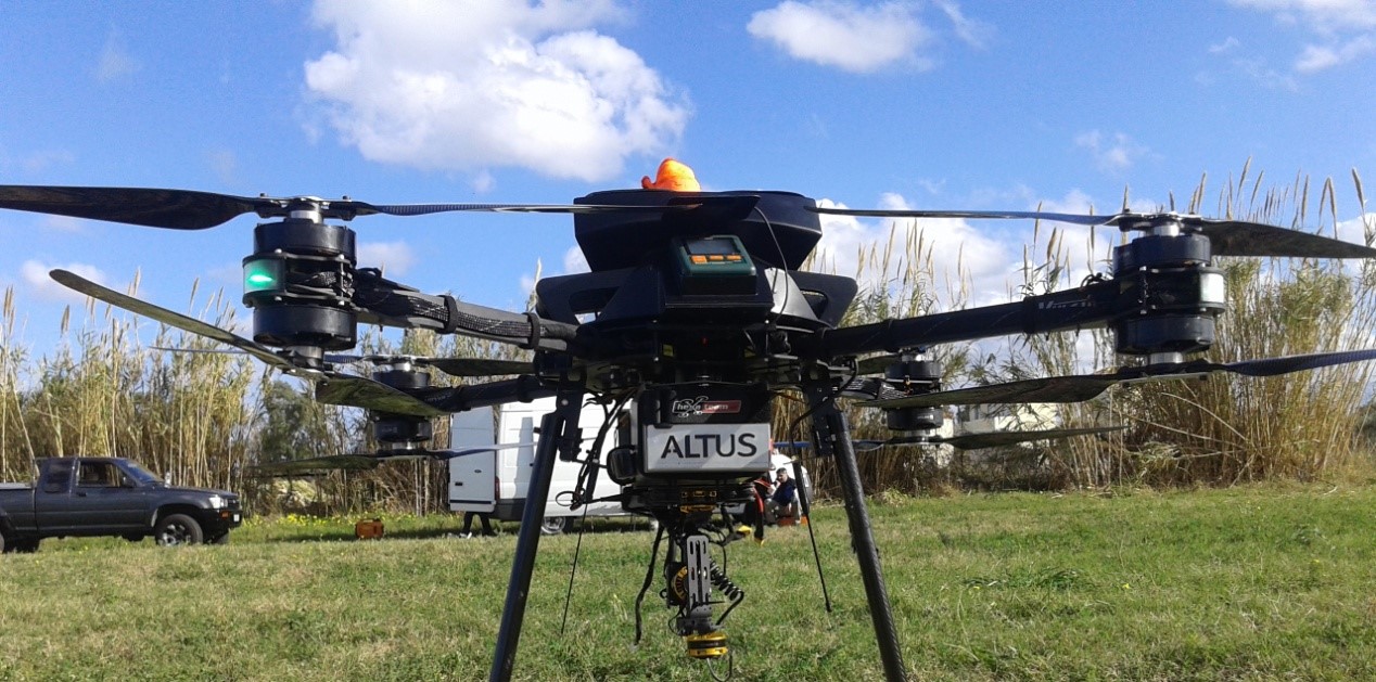 ALTUS LSA successfully delivered the ATLAS 8 octacopter VTOL UAV, an unmanned UAV octacopter that aims in illustrating the distribution of air pollution in order to assess large episodes and the timely recording of a transboundary pollution component (eg Saharan dust, fire tassels from fires, volcanic eruptions, industrial accidents, etc). VTOL UAV was realized through KRIPIS – PROTEAS program and BEYOND Program is benefited by its operational activity. The octacopter system is based on a user friendly approach and through the Autopilot System and the UAS navigation software, the platform can be completely autonomous while on air, following the pre-determined flight plan set by the operator prior to the flight. The specific version of the UAV was especially configured to meet the N.O.A. operational and technical requirements, as a tailored turnkey solution. Four members of N.O.A. have been certified as ATLAS UAV operators after successfully completing the one-week theoretical and practical (hands-on) training program.
BEYOND RACK
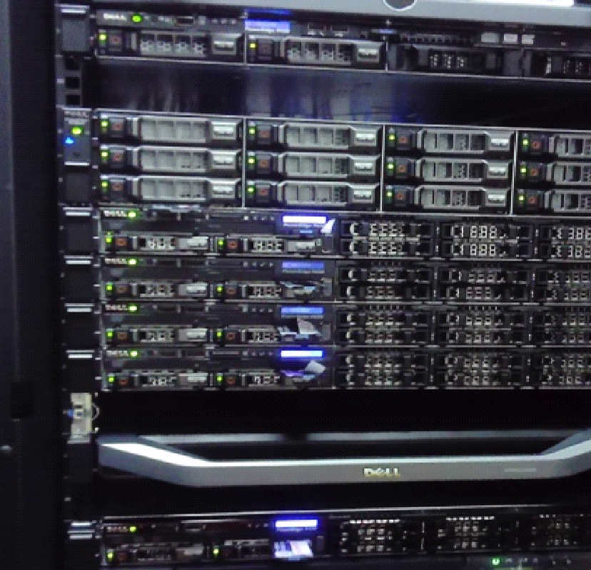 Beyond Centre of excellence designs, deploys and maintains computational infrastructure in order to support users and implement projects and services assigned. The main infrastructure consists of a "Virtualization" System. This is a cluster of four Red Hat Enterprise Hypervisors servers that simulate 27 virtual machines which serve the variety of needs to be met for the provision of services and the execution of tasks. The system with high availability features offers uninterrupted operation of all its individual parts with expansion and reconfiguration capabilities.
Infrastructure also includes Storage and Archiving Systems in order to meet its storage and data sharing needs. The main Storage System consists of a PowerEdge server and a 30 disks arrangement, providing a total payload of 100 TB. There is also a Synology DiskStation NAS Storage with a total capacity of 20 TB, supporting a 10GbE network interface card and numerous RAID configurations. It offers a user-friendly management console and plenty of media server, backup, mail server, and cloud synchronization apps, and it is whisper quiet.
Additionally, a new cluster consisting of three powerful Dell Servers with extra processing capabilities and a common Dell PowerVault Storage has been added recently to NOA infrastructure. Those servers are intended to serve the needs of services that will be provided continuously and in 24/7 operation within the EFFIS project assigned to ΝΟΑ. This project aims to support data exchange within the framework of the European Commission's Global Monitoring for Environment and Security Program (Copernicus). The area of responsibility of the service assigned is the entire European Union, the Balkans, North Africa and the Middle East.
Meteosat Second Generation SEVIRI Ground Station System
Since 2007, the Institute has installed and has been using on a 24/7 operational basis a ground station for systematically receiving satellite imagery from the MSG-SEVIRI system maintained by EUMETSAT. The operating agreement for the collection, archiving, and exploitation for research purposes of MSG images, signed between IAASARS and EUMETSAT, was recently renewed in 2017. On an operational level, the main application of the MSG/SEVIRI ground station is the detection, monitoring and mapping of forest wildfires in near-real time (every 5 minutes) for the entire Greek territory, the briefing of the public authorities and stakeholders involved in the management and suppression of wildfires, and informing the citizens whose properties are threatened by ongoing catastrophic fire events (http://ocean.space.noa.gr/fires).
Ground Segment Data Hub
 Within the BEYOND project, a first version of BEYOND Collaborative Ground Segment Data Site was released on January 2016 under the auspices of NOA-IAASARS. It is available to public from the following URL: http://groundsegment.space.noa.gr/. The BEYOND Collaborative Ground Segment Data Site is a web based system designed to provide EO data to users with Cataloguing, Searching, Viewing and Downloading capabilities from contemporary satellites. Its strengths are: (i) user friendly web-enabled graphical user interface (GUI) and (ii) clean separation with backend functionalities. Searching procedure involves: (i) the selection of a satellite, (ii) the selection of an instrument, (iii) the selection of a product, and (iv) the selection of a date range to search for products that became available (i.e. ingested) during that range. The search function returns a list of the available products, alongside with useful info (metadata). It offers a Straight-forward download of the product. Some other features that will be available in the future are: (i) more filter options, (ii) customized sorting, and (iii) on the fly compress/download of multiple products.
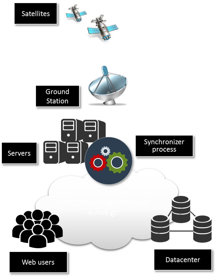
The ground segment architecture is based on the N-tier paradigm.
- The 1st tier is comprised of the ground station and the servers used for acquisition and processing.
- The 2nd tier is comprised of the datacenter and the backend processes used to extract and store metadata in the catalogues (e.g. Synchronizer process).
- The 3rd tier constitutes the frontend that is used to allow the users to search, view and download products. Ground Segment on the cloud!