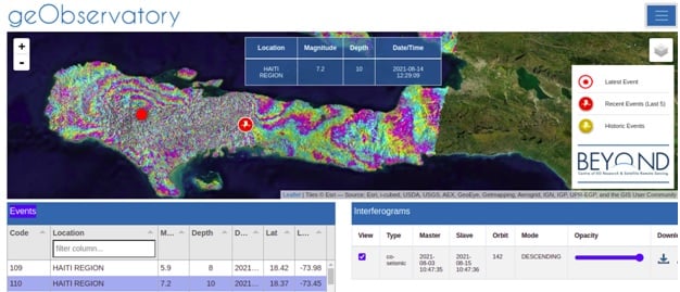
First co-seismic interferogram of Haiti region earthquake.
On August 14, 2021, 12:29:09 UTC a strong earthquake of M7.2, occurred in Haiti region. It was followed by a second seismic event of M5.9, on August 15, 2021, 03:20:45 UTC. The geObservatory service of BEYOND Center of Earth Observation Research and Satellite Remote Sensing of the National Observatory of Athens, was activated and mapped ground deformation in the affected region. Sentinel-1 SLC images of descending track 142, of August 3, 2021 and August 15, 2021, were used to produce the first co-seismic interferogram, where deformation of both seismic events is mapped. Each fringe in the interferogram corresponds to ground deformation equal to 2.8 cm. All co-seismic and pre-seismic interferograms, associated with the events are freely available in the geObsevatory website (http://geobservatory.beyond-eocenter.eu/). The website will be updated with new interferograms as long as new Sentinel-1 satellite data becomes available at the Hellenic Mirror Site.