
 |
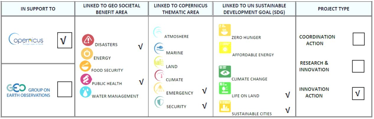
FRAMEWORK SERVICE CONTRACT FOR COPERNICUS EMERGENCY The European Forest Fire Information System (EFFIS) Program Call for tender JRC/IPR/2014/G.2/0012/OC 2018-2012, GA 259811 696.000 EUR |
The European Forest Fire Information System (EFFIS) supports the services in charge of the protection of forests against fires in the EU countries and provides the European Commission services and the European Parliament with updated and reliable information on wild land fires in Europe. A number of specific applications are available through EFFIS. EFFIS is one of the components of the Emergency Management Services in the EU Copernicus program. EFFIS also supports the global level into a Global Wilfire Information System (GWIS). The project engages BEYOND Center of Excellence in this context, for providing the EFFIS system with timely, reliable and accurate satellite based fire data over Europe, Middle East and North Africa concerning: Active Fires (hot spots) and Burned areas (fire perimeter) in real time as soon as a satellite image from the multitude of sensors accessed by the BEYOND Center acquisition antennas and data hubs becomes available (e.g. EOS Aqua/Terra, NPP, FY, Sentinel-2, Sentinel-3). Advanced research has been conducted in BEYOND for adaptation and validation of the FIREHUB/BEYOND system to meet the operational chacteristics and accuracy standards of the required service.
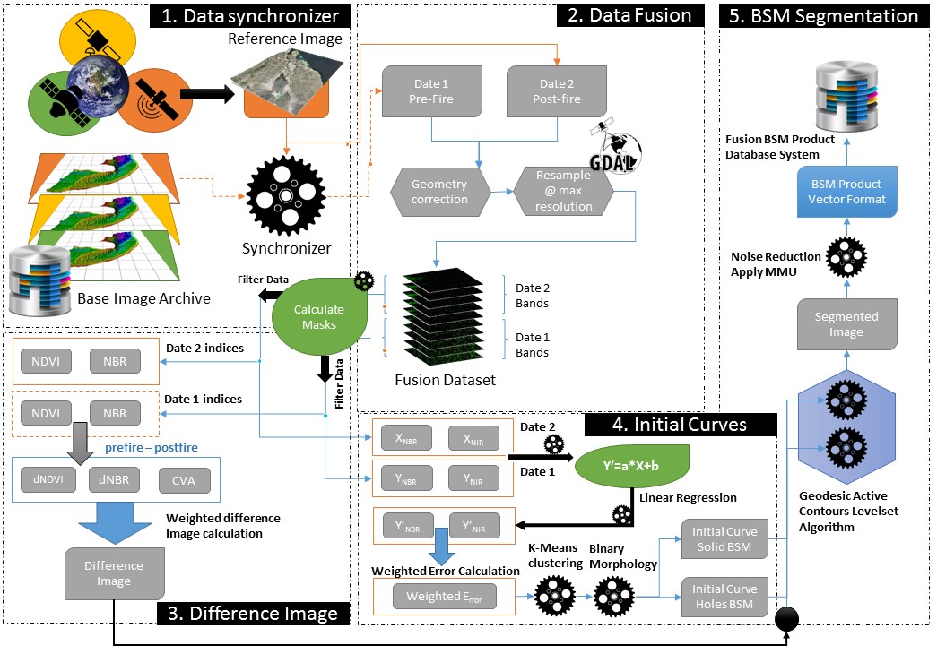
The algorithm used for automated Burnt Scar extraction, applicable for both middle (e.g. VIIRS, MODIS, FengYun-3, Sentinel-3) and high resolution satellite systems (e.g. Sentinel-2) is based on an implementation of the Liu et al, 2014 publication “Study of Burn Scar Extraction Automatically Based on Level Set Method using Remote Sensing Data”. Further modifications and optimizations were applied in order to produce more accurate results and minimize omission and commission error rates, as well as to adapt the proposed algorithm to the heterogeneous satellite systems and their specific data analysis requirements.
The main advantages of the algorithm are the following:
- Enhanced histogram matching between master and reference spectral bands by applying cascaded local standardization techniques which furthermore amplify local minima/maxima that in turn distinguish burnt scar areas thus resulting to significantly improved classification of burned/non burned areas.
- Integration of diverse index capacities to better characterize the different levels of burn severity and to further extract the burnt scar product.
- Utilization of Level Set Methods (LSM) for the classification of burnt and non-burnt areas, as one of the most state-of-the-art segmentation approaches. Level set methods are implicit, parameter free, provide a direct way to estimate the geometric properties of the evolving structure, can change the topology and are intrinsic. These methods are ideal for Burnt Scar Mapping (BSM) extraction as they are spatially-aware and converge automatically, they are designed for problems which have topological changes, curvature dependence, singularities formation and issues which appear in interface propagation techniques (Bhaidasna and Mehta, 2013). Among many techniques developed to derive burnscar information from remote sensing data, such as fixed thresholding or post-classification techniques using the OSTU algorithm, Fuzzy C-Mean (FCM) algorithm etc., the implemented approach can extract the outline curve of fire burn scar more effectively and exactly. The method has higher extraction accuracy and less algorithm complexity than that of the conventional methods. Compared to fixed threshold approaches, where the algorithm discriminates burn scar from neighbouring objects with empirically derived fixed sets of thresholds, this method clearly prevails because it “chooses” the appropriate local thresholds, as mentioned earlier. A fast and robust implementation of the Geodesic Active Contour Level set Method (Leventon et al, 2000) is utilized while Liu suggests the use of Chan and Vese levelset segmentation algorithm (Chan and Vese, 2001). The evaluation of the Geodesic Active Contour Level set Method gave better results than the proposed by Liu method.
- The core algorithm is highly adaptable to available optical sensors for burnt scar product extraction, provided that those sensors at least provide visible red, near-infrared and short-wave-infrared bands.
Algorithmic Procedure Diagram
References
- Bhaidasna Z., Mehta S. (2013) A review on level set method for image segmentation. Int. J. Comput Appl 63(11):20–22.
- Chan T, Vese L (2001) Active contours without edges. Image Processing, IEEE.Transactions on 10: 266–277.
- Leventon, M.E., Grimson, W.E.L., and Faugeras, O. (2000) Statistical shape influence in geodesic active contours. In Proc. Conf. Computer Vis. and Pattern Recog., Hilton Head Island, SC, vol. 1, pp. 316–323. June 13–15.
- Liu Y, Dai Q, Liu J, Liu S, Yang J (2014) Study of Burn Scar Extraction Automatically Based on Level Set Method using Remote Sensing Data. PLoS ONE 9(2): e87480. doi:10.1371/journal.pone.0087480