ΕΜΠΡΟΣ - Προηγμένες Τεχνολογίες Παρατήρησης της Γης και Πληροφορικής για την Έγκαιρη Μελέτη και Προειδοποίηση Μεταδιδόμενων Νοσημάτων μέσω Κουνουπιών. NEWSLETTER 3
Μπορείτε να διαβάσετε το Newsletter εδώ.
ΕΜΠΡΟΣ - Προηγμένες Τεχνολογίες Παρατήρησης της Γης και Πληροφορικής για την Έγκαιρη Μελέτη και Προειδοποίηση Μεταδιδόμενων Νοσημάτων μέσω Κουνουπιών. NEWSLETTER 3
Μπορείτε να διαβάσετε το Newsletter εδώ.
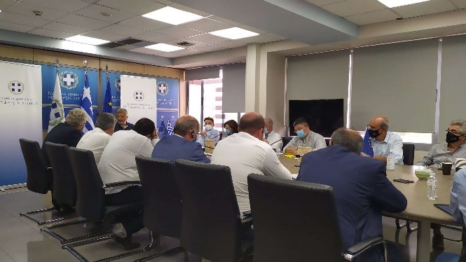
Στο πλαίσιο της από 3/3/2021 Προγραμματικής Σύμβασης μεταξύ της Περιφέρειας Αττικής και του Εθνικού Αστεροσκοπείου Αθηνών (Ε.Α.Α.) (Α’ Μέρος) που αξιοποιεί το επιστημονικό και ερευνητικό δυναμικό της Επιχειρησιακής Μονάδας «Κέντρο Επιστημών Παρατήρησης της Γης και Δορυφορικής Τηλεπισκόπησης BEYOND» του Ινστιτούτου Αστρονομίας, Αστροφυσικής, Διαστημικών Εφαρμογών & Τηλεπισκόπησης (Ι.Α.Α.Δ.Ε.Τ.), για την εκπόνηση έρευνας με τίτλο «Εκτίμηση κινδύνων σεισμού, πυρκαγιάς και πλημμύρας στην Περιφέρεια Αττικής», με χρηματοδότηση της Περιφέρειας Αττικής, πραγματοποιήθηκε στις 21 Σεπτεμβρίου 2021 σχετικό εκπαιδευτικό σεμινάριο.
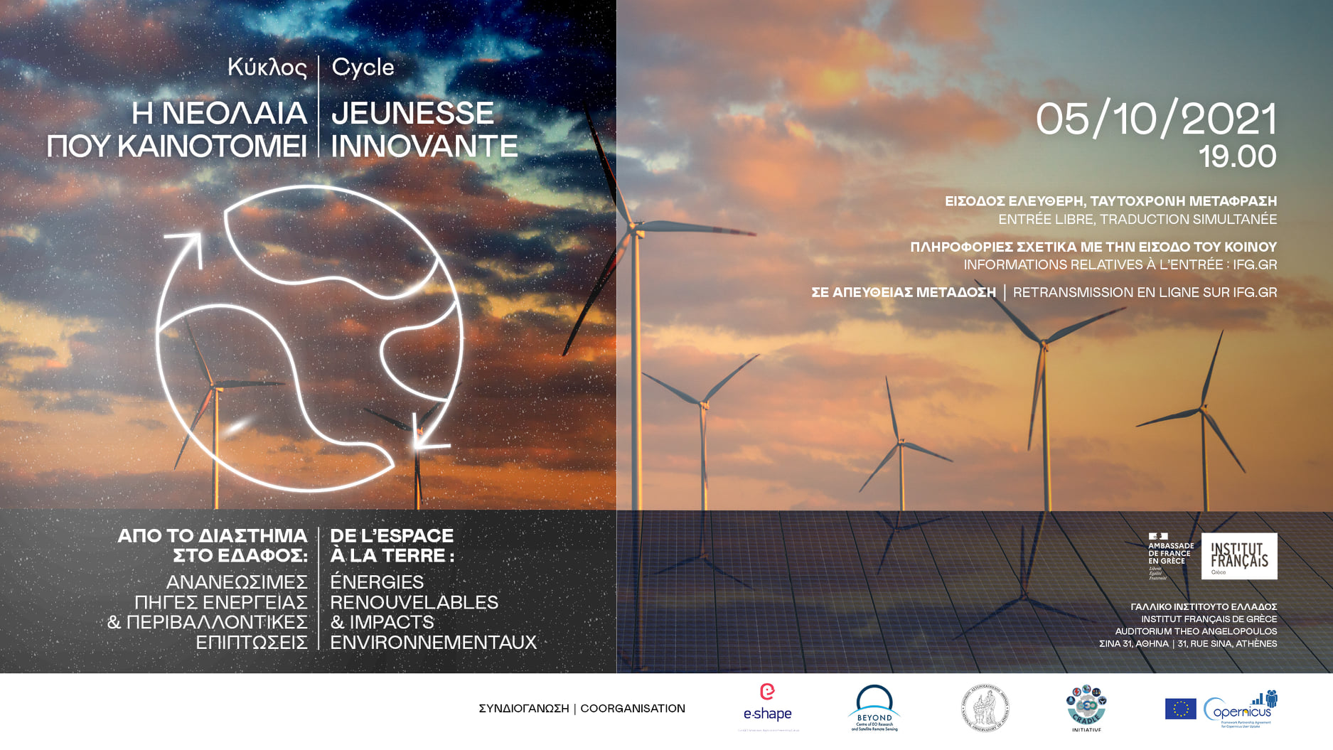
Το Κέντρο Επιστημών Παρατήρησης της Γης & Δορυφορικής Τηλεπισκόπησης "BEYOND" του Ινστιτούτου Αστρονομίας Αστροφυσικής Διαστημικών Εφαρμογών και Τηλεπισκόπησης του Εθνικού Αστεροσκοπείου Αθηνών σε συνεργασία με το Γαλλικό Ινστιτούτο Αθηνών, το Center for Observation, Impacts, Energy of MINES ParisTech και το Paris Sciences & Lettres (PSL) University, διοργανώνουν Ημερίδα με κεντρικό θέμα "Από το διάστημα στο έδαφος – Ανανεώσιμες πηγές ενέργειας και περιβαλλοντικές επιπτώσεις".
6 επιστήμονες από Ελλάδα και Γαλλία συζητούν για το παραπάνω θέμα στο Γαλλικό Ινστιτούτο Αθηνών στις 5 Οκτωβρίου 2021 (19:00 – 21:00), στο Αμφιθέατρο Theo Angelopoulos (Γαλλικό Ινστιτούτο).
Η εκδήλωση είναι με είσοδο ελεύθερη (θα ακολουθηθεί το σχετικό υγειονομικό πρωτόκολλο - περιορισμένες θέσεις λόγω Covid-19) και σε απευθείας μετάδοση διαδικτυακά.
Θα επανέλθουμε σύντομα με περισσότερες πληροφορίες σχετικά με το πρόγραμμα της εκδήλωσης.
*Η ημερίδα διοργανώνεται στο πλαίσιο των δραστηριοτήτων του έργου e-shape (EuroGEO Showcases: Applications Powered by Europe - Horizon 2020 research and innovation programme under grant agreement 820852) και του FPCUP (Caroline Herschel Framework Partnership Agreement on Copernicus User Uptake –European Commission, FPA no.: 275/G/GRO/COPE/17/10042)
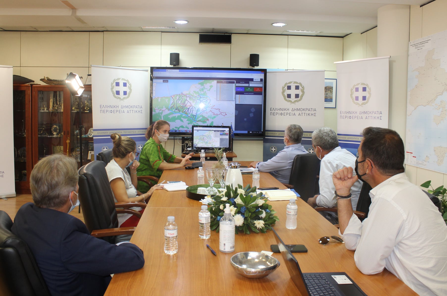
Την πρώτη μελέτη που αφορά στην υδρολογική λεκάνη Αιγειρουσών-Αλεποχωρίου σχετικά με τις επιπτώσεις των πρόσφατων πυρκαγιών και τους πιθανούς πλημμυρικούς κινδύνους στην περιοχή, παρέδωσε το Αστεροσκοπείο Αθηνών στην Περιφέρεια Αττικής.
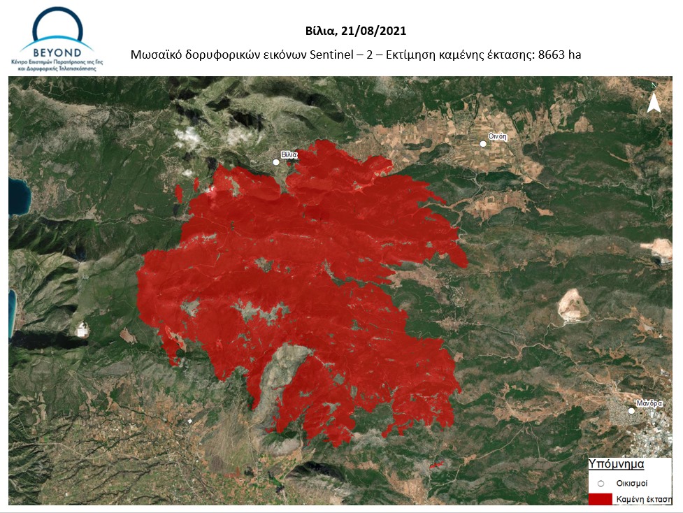
Νέα εκτίμηση της καμένης έκτασης στην περιοχή των Βιλίων, ύστερα από επεξεργασία (χαρτογράφηση) δύο εικόνων υψηλής ανάλυσης Sentinel-2.
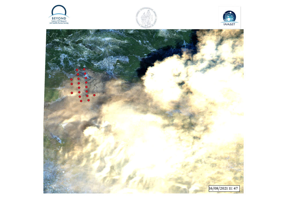
Στο βίντεο βλέπουμε την εξέλιξη των ενεργών εστιών της πυρκαγιάς στα Βίλια Αττικής από την έναρξη στις 16/08/2021 εώς και σήμερα 19/08/2021. Οι ενεργές εστίες έχουν προκύψει από επεξεργασία δορυφορικών εικόνων VIIRS και MODIS. Στο πρώτο frame παρουσιάζεται η εικόνα Sentinel-2 με ημερομηνία λήψης 18/08/2021 και ώρα 09:05 UTC, όπου φαίνεται και το μεγάλο νέφος καπνού που έχει αναπτυχθεί. Το σύνολο των ενεργών εστιών που έχουν καταγραφεί στο διάστημα αυτό εμφανίζονται στο τελευταίο frame.
H πυρκαγιά στα Βίλια βρίσκεται ακόμη σε εξέλιξη. Το γεγονός ξεκινησε στις 16 Αυγούστου 2021.
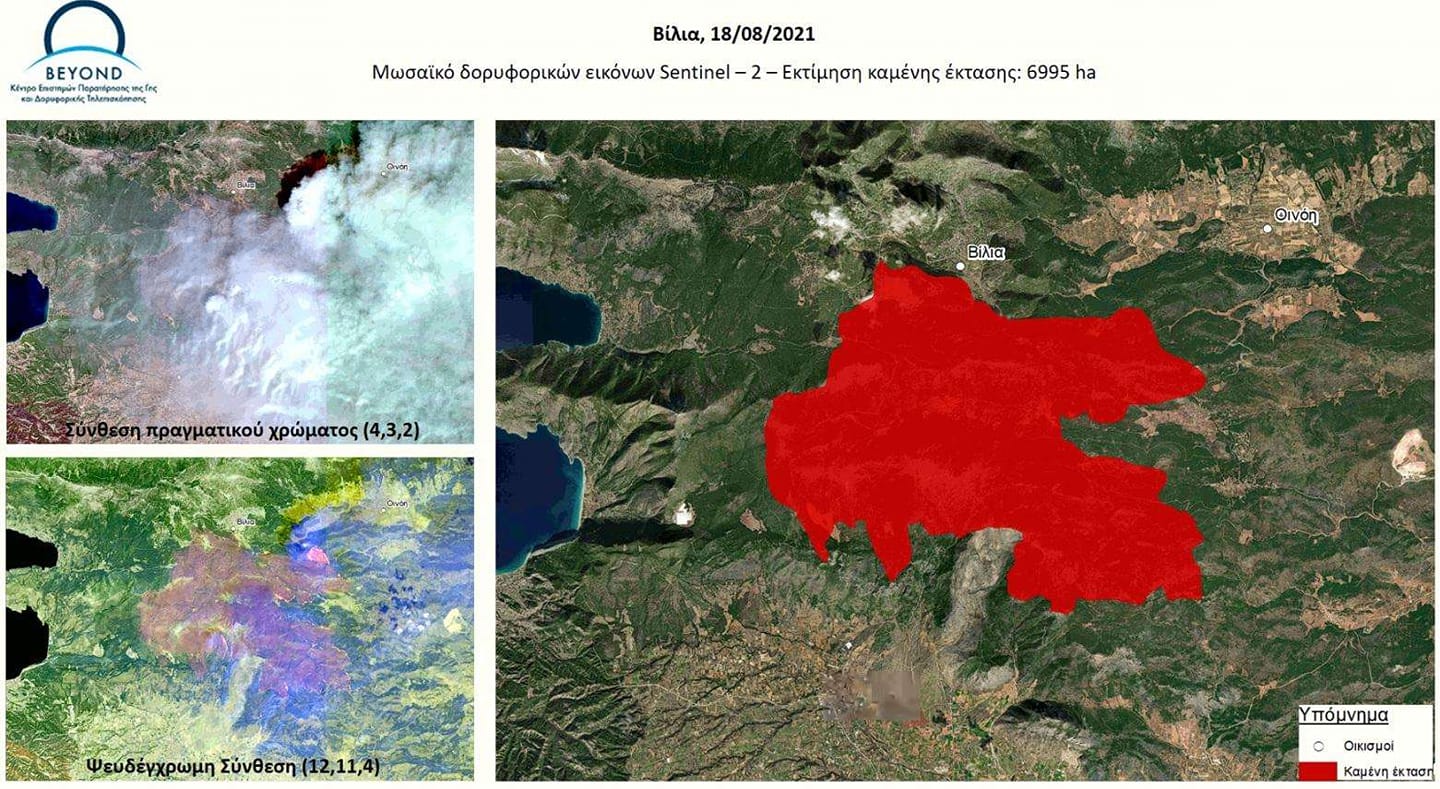
Ακολουθεί, μωσαϊκό 2 δορυφορικών εικόνων υψηλής ανάλυσης Sentinel- 2 με ημερομηνία λήψης 18/8/2021 και ώρα λήψης 12:05 τοπική. Η εκτίμηση βασίστηκε στην ψευδέγχρωμη σύνθεση. Η εκτιμώμενη έκταση είναι 6.995 εκτάρια (69.950 στρέμματα).
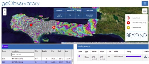
First co-seismic interferogram of Haiti region earthquake.
On August 14, 2021, 12:29:09 UTC a strong earthquake of M7.2, occurred in Haiti region. It was followed by a second seismic event of M5.9, on August 15, 2021, 03:20:45 UTC. The geObservatory service of BEYOND Center of Earth Observation Research and Satellite Remote Sensing of the National Observatory of Athens, was activated and mapped ground deformation in the affected region. Sentinel-1 SLC images of descending track 142, of August 3, 2021 and August 15, 2021, were used to produce the first co-seismic interferogram, where deformation of both seismic events is mapped. Each fringe in the interferogram corresponds to ground deformation equal to 2.8 cm. All co-seismic and pre-seismic interferograms, associated with the events are freely available in the geObsevatory website (http://geobservatory.beyond-eocenter.eu/). The website will be updated with new interferograms as long as new Sentinel-1 satellite data becomes available at the Hellenic Mirror Site.
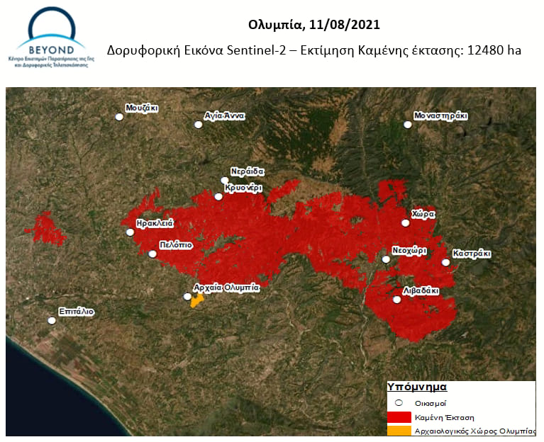
Νέα εκτίμηση της καμένης έκτασης στην ευρύτερη περιοχή της Ηλείας και Αρκαδίας. 12.480 εκτάρια εκτιμήθηκε η καμένη έκταση σύμφωνα με την επεξεργασία εικόνας υψηλής ανάλυσης Sentinel-2 (λήψη εικόνας 11/8, 12.20 τοπική).
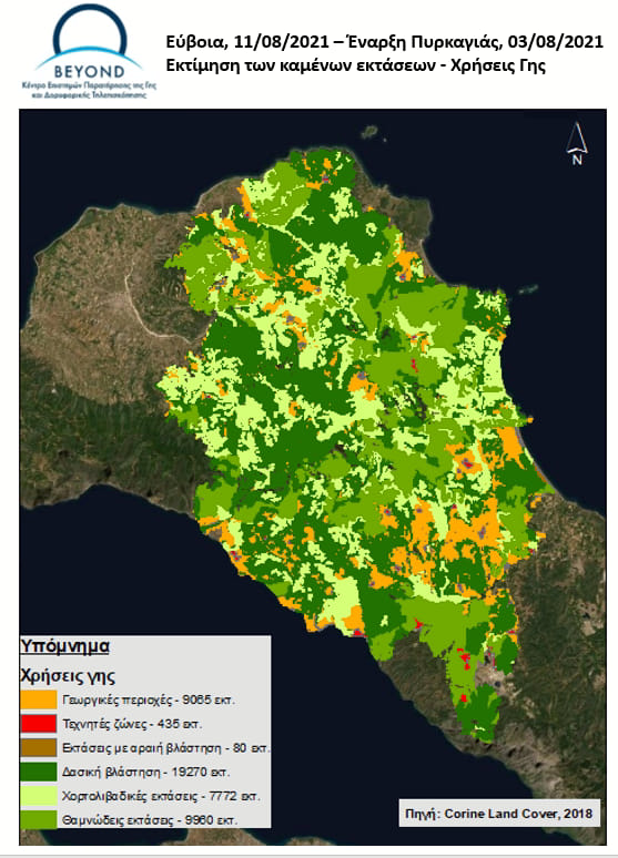
Xάρτης χρήσεων γης της Εύβοιας για την περιοχή που έχει πληγεί από την πυρκαγιά (Πηγη:Corine Land Cover 2018)
Οι εκτάσεις που έχουν καεί αφορούν:
Γεωργικές περιοχές - 9065 εκτ.
Τεχνητές ζώνες - 435 εκτ.
Εκτάσεις με αραιή βλάστηση - 80 εκτ.
Δασική βλάστηση - 19270 εκτ.
Χορτολιβαδικές εκτάσεις - 7772 εκτ.
Θαμνώδεις εκτάσεις - 9960 εκτ.