geo1

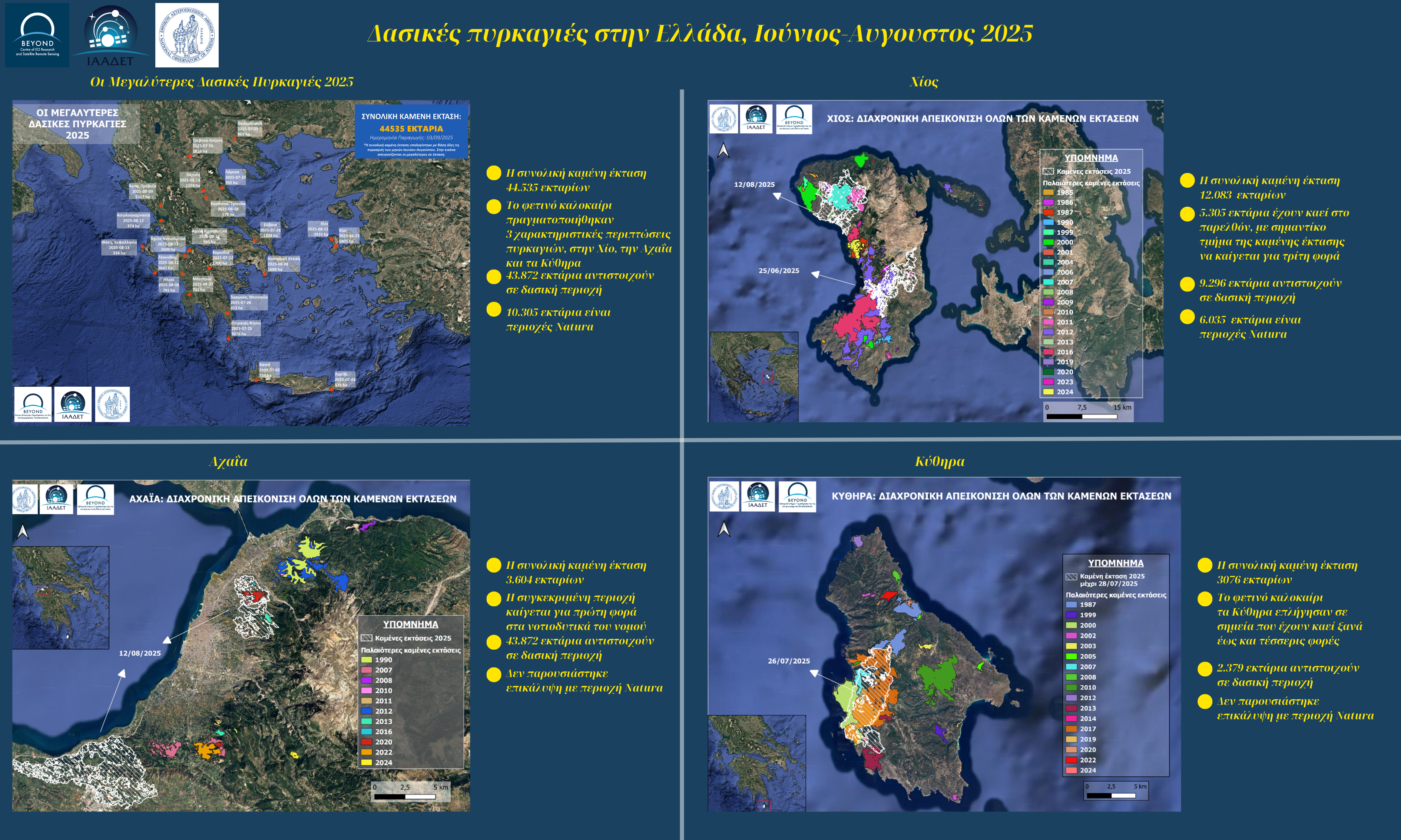
Haris Kontoes GRSS GEO Principal, informed the Board about the interesting outcomes of the Technology, Industry and Education (TIE) session that he co-organised with Prof. Megan Lewis in IGARSS 2025, entitled “Advances and applications in Earth Observation for SDG. Accelerating Earth Intelligence in the context of GEO” on 6 August 2025 in Brisbane, Australia. This event brought together GRSS and GEO experts from industry, academia, and user communities, and discussed key synergies at regional and global level to address challenges in capacity building and development of solutions for accelerating applications in the global scale.

 RESEARCHERS NIGHT 2025


Ένα μεγάλο ευχαριστώ σε όλους όσους επισκέφθηκαν το περίπτερό μας κατά τη διάρκεια της φετινής Βραδιας του Ερευνητή την Παρασκευή 26 Σεπτεμβρίου!


EO4Health User Forum 2025 KV 711x400

The European Space Agency (ESA), in the framework of EO Science for Society successfully hosted the EO4Health User Forum from 22–25 September 2025 at the headquarters of the World Organisation for Animal Health (WOAH) in Paris. During the session, “Water-Borne Diseases – Users and Stakeholders” Dr. Haris Kontoes, Research Director of the BEYOND Centre at ISAARS/NOA and Coordinator of the EuroGEO Action Groups, presented the EuroGEO initiative underlining its role in advancing Europe’s innovation capacity in Earth Observation sector and its contribution to the implementation of European and global climate policies, including the EU Green Deal.

Στις 18 Σεπτεμβρίου 2025, πραγματοποιήθηκε στην Αθήνα η ημερίδα "Athens Space Safety Industry Briefing 2025", που διοργανώθηκε από την Ευρωπαϊκή Υπηρεσία Διαστήματος (ESA) σε συνεργασία με το Υπουργείο Ψηφιακής Διακυβέρνησης. 

Η εκδήλωση είχε στόχο την ενημέρωση της ευρωπαϊκής βιομηχανίας για τις εξελίξεις και τις δυνατότητες συνεργασίας στο πλαίσιο της στρατηγικής Space Safety της ESA.

Κατά τη διάρκεια της συνάντησης, ο Δρ. Χάρης Κοντοές, Διευθυντής Ερευνών του Εθνικού Αστεροσκοπείου Αθηνών και επικεφαλής του BEYOND Centre of Excellence, παρουσίασε το έργο του Εθνικού Κέντρου Επιχειρήσεων SST της Ελλάδας, με τίτλο:

“Space Surveillance & Tracking – Operations, Research, and Future Vision for Greece” 

 csm fpcup ch zoom 0d12d9feee

Το διαδικτυακό σεμινάριο με τίτλο: «Copernicus και Τεχνολογίες Τηλεπισκόπησης για την Προστασία της Πολιτιστικής Κληρονομιάς και την Παρακολούθηση Κινδύνου» που συνδιοργάνωσε το BEYOND με το Δίκτυο ΠΡΑΞΗ/ΙΤΕ στις 18 Σεπτεμβρίου 2025, αφορούσε στην εκτίμηση κινδύνου και τη διαχείριση εκτάκτων αναγκών, με έμφαση στα μνημεία πολιτιστικής κληρονομιάς. Από τις συνολικά 60 εγγραφές, σχεδόν το 1/3 συμμετείχε διαδικτυακά.

Κατά τη διάρκεια της παρουσίασης, η ομάδα του BEYOND παρουσίασε τη μεθοδολογία που ακολουθήθηκε καθώς και τα αποτελέσματα του σχεδίου διαχείρισης κινδύνου και έκτακτης ανάγκης κοντά σε πολιτιστικούς και αρχαιολογικούς χώρους, εστιάζοντας στην περιοχή της Αρχαίας Ολυμπίας.

Η ανταπόκριση των συμμετεχόντων, κυρίως μελών του Υπουργείου Πολιτισμού της Ελλάδας και της Ακαδημαϊκής κοινότητας, επικεντρώθηκε στο πώς θα μπορούσαν να ενσωματωθούν ακόμα περισσότεροι παράγοντες κινδύνου στη μελέτη και πώς αυτή η έρευνα θα μπορούσε να επεκταθεί και σε άλλους αρχαιολογικούς χώρους.

Διαβάστε περισσότερα: https://www1.fpcup.eu/events/events-details/online-event-copernicus-and-eo-technologies-in-cultural-heritage-protection-and-risk-monitoring-785


ROUMANIA FPCUP


Στις 12 Σεπτεμβρίου 2025, το BEYOND σε συνεργασία με το Δίκτυο ΠΡΑΞΗ/ΙΤΕ και με την υποστήριξη των Romanian Space Agency (ROSA) & Meteo Romania, συνδιοργάνωσε διαδικτυακό εργαστήριο στο πλαίσιο του ευρωπαϊκού προγράμματος FPCUP, με στόχο τη μεταφορά τεχνογνωσίας για την αξιοποίηση υπηρεσιών Copernicus σε πλημμύρες και δασικές πυρκαγιές.

Αρχικά πραγματοποιήθηκαν παρουσιάσεις, με έμφαση στις υπηρεσίες FloodHUB και FireHUB, και ακολούθησε hands-on εκπαίδευση σε πλατφόρμες παρακολούθησης Copernicus, ενισχύοντας τις επιχειρησιακές δυνατότητες των συμμετεχόντων για ετοιμότητα και απόκριση σε φυσικές καταστροφές.


 πυρκαγίες στην Ελλάδα Ιούνιος Αυγουστος 2025 003

Η ερευνητική ομάδα της Επιχειρησιακής Μονάδας BEYOND του Εθνικού Αστεροσκοπείου Αθηνών εκπόνησε το παρόν report με στόχο την καταγραφή και ανάλυση των δασικών πυρκαγιών που έπληξαν την Ελλάδα κατά τη θερινή περίοδο του 2025. Κατά τη διάρκεια αυτής της περιόδου, το Πυροσβεστικό Σώμα κατέγραψε μεγάλο αριθμό περιστατικών, ενώ το European Forest Fire Information System (EFFIS) της Ευρωπαϊκής Επιτροπής χαρτογράφησε 49 πυρκαγιές με καμένη έκταση άνω των 50 εκταρίων. Η ομάδας μας, αξιοποιώντας δορυφορικά δεδομένα Sentinel-2 του Ευρωπαϊκού Προγράμματος Copernicus EU, με χωρική ανάλυση έως 10 μέτρα για την ακριβή χαρτογράφηση των καμένων εκτάσεων και μέσω της ανάλυσης χρήσης γης στις πυρόπληκτες εκτάσεις με δεδομένα του CORINE Land Cover 2018 και εκτίμηση της επικάλυψής τους με το δίκτυο προστατευόμενων περιοχών NATURA 2000, παρέχει μια ολοκληρωμένη εικόνα των επιπτώσεων των πυρκαγιών για το καλοκαίρι του 2025.

BANNER 


Following the successful organization of IGARSS 2024 in Athens, The Operational Unit “BEYOND Centre of Earth Observation Research and Satellite Remote Sensing” of the National Observatory of Athens (NOA), actively contributed to IGARSS 2025 with a high-level session organization and participation, oral presentations, and posters. The International Geoscience and Remote Sensing Symposium (IGARSS) 2025, the flagship conference of the IEEE Geoscience and Remote Sensing Society (GRSS), took place on 3–8 August 2025 in the vibrant city of Brisbane, Australia. With the theme “One Earth”, this year’s edition highlighted the urgent need to address global environmental threats and to foster collaborative solutions through remote sensing and Earth observation technologies.

Untitled design(6).png


The Mediterranean region is facing an alarming rise in the frequency and severity of wildfires, threatening ecosystems, communities, and livelihoods. In response, BEYOND Centre of Earth Observation Research and Satellite Remote Sensing (BEYOND/NOA) is proud to coordinate the MedFireWise Project—a new, ambitious 36-month project under the Interreg NEXT MED programme aimed at advancing wildfire risk management across the Mediterranean basin.

Launched on June 19, 2025, and co-funded by the European Union, the MedFireWise Project promotes Nature-based Solutions (NbS)—namely prescribed burning and silvopasture—as sustainable and scientifically supported practices to mitigate wildfire risk and strengthen ecosystem resilience.

We're excited to announce that the successful collaboration between our team from NOA/BEYOND, NTUA, and IDCOM, under the supervision of JRC CEMS, has resulted in valuable scientific insights on post-wildfire vegetation recovery surveillance in Sierra Bermeja, Spain. State of vegetation and forest mass, erosion risk, landslide risk and road network accessibility mapping were assessed in order to monitor the recovery of the environment and to provide information on the risk to accommodate the use and services of the impacted territory.